
Project ECO2s: Geologic Characterization and Preliminary Storage Capacity Estimates
Carbon Management Technology Conference
2017
2017 Carbon Management Technology Conference
General Submissions
Session 15 - Storage Characterization
Thursday, July 20, 2017 - 11:30am to 12:00pm
The Project ECO2S characterization team, in conjunction with Mississippi Power Company and Southern Company Services, has undertaken considerable carbon dioxide (CO2) storage pre-feasibility work to ensure that the Kemper County energy facility, located in central Mississippi, USA, has access to high potential, commercial-scale capacity for storing CO2. In this presentation, we will showcase the geologic characterization of the 30,000 acre area adjacent to the facility, named the Project ECO2S storage complex, preliminary capacity estimates and the results of field results gathered to date.
As part of this work, the team: (1) evaluated structural risks; (2) collected and analyzed available subsurface information to confirm the adequacy of the depth, thickness, porosity, and injectivity of potential CO2 storage reservoirs at the proposed storage site; (3) established the rock properties, regional extent and thickness of the shale intervals that compromise the CO2 confining system; and (4) prepared a preliminary volumetric calculation and simplified simulation of the size and storage capacity of the CO2 storage complex.
Central and southern Kemper County, contains the junction of the Paleozoic Ouachita orogenic belt from the west and the Appalachian thrust belt from the east (Pashin et al., 2008). Structure in the Paleozoic section is complex as a result. A regional scale angular unconformity overlies the Paleozoics and a thick section of Cretaceous and Tertiary age sediments of the northern Gulf of Mexico Basin onlap the Paleozoic units to the northeast. Cretaceous reservoir units include the lower Tuscaloosa Group’s ‘Massive sand’, the Washita-Fredericksburg interval, and the Paluxy Formation, contain porous and permeable clastic reservoirs that appear to have CO2 storage potential as well as multiple internal and overlying confining units (Figure 1).
The ‘Massive sand’, which lies at the base of the Lower Tuscaloosa Group is primarily comprised of sandstone and is approximately 250 ft thick, with an average porosity of 20%. The upper portion of the Washita-Fredericksburg interval, contains principally sandstone, conglomerate, and shale. The middle section of the Washita-Fredericksburg, locally referred to as the ‘Big Fred sand’ contains more than 90 percent sandstone and can approach a thickness of 300 feet. Overall the Washita-Fredericksburg interval contains over 600 ft of net sandstone, with an average porosity of 18%. The Paluxy Formation is the deepest Cretaceous reservoir, forming the base of the Mesozoic section throughout Kemper County. The Paluxy Formation contains 18% average porosity across 400 ft of net sandstone.
The ‘Marine Tuscaloosa shale’ directly overlies the ‘Massive sand’ and is a widespread marker consisting primarily of shale and will serve as a confining zone for CO2 storage. A prominent shale interval which marks the base of the Washita Fredericksburg interval will serve as a confining zone and it can be correlated throughout the storage complex.
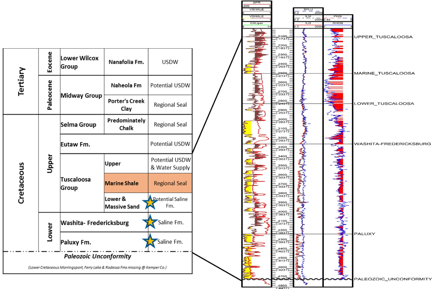
Figure 1. Generalized Stratigraphy (left) and type log (right, F.M. Legette #1), for the Project ECO2S Storage Complex.
The complex’s capacity was evaluated using volumetric and screening-level plume modeling approaches, both demonstrating potential to store commercial scale CO2 volumes. The US-DOE methodology for site specific saline reservoir CO2 storage capacities was utilized. Results suggest that the three reservoirs in the storage complex have a storage capacity of 136 to 438 million metric tonnes. The results of the screening-level plume model suggest that the storage complex may be able to store 90 million metric tonnes of CO2 within 7,000 to 10,000 acres.
The project ECO2S CarbonSAFE Phase II characterization program is designed to address information gaps to further ensure safe, long term storage. Whole core from potential storage reservoirs and overlying confining units and full suites of geophysical logs will be gathered from the new project wells. Laboratory work will establish the rocks’ mineralogy, porosity, permeability, and mechanical properties. Additional laboratory geologic characterization efforts will include modeling of rock-water-CO2 chemical reactions, confining unit studies, and tests of the flow capacity of the reservoir at varying water. These core and laboratory data will then be used to update our current understanding of the geologic framework within and beyond the storage complex. The geologic model will be then used as a foundation for large scale simulations to better understand how a CO2 plume might develop and move within the subsurface at the Storage Complex as well as the pressure buildup.